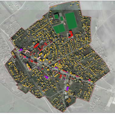
Infra Plus provides high-precision geodetic and GIS mapping services using advanced surveying and drone technology to support infrastructure and urban development. Our expertise includes land surveying, cadastral mapping, 3D modeling, GIS data collection, and drone-based topographic measurements for accurate and efficient project planning.
We specialize in aerial drone surveys and project supervision, offering real-time monitoring, progress tracking, and quality control for construction, roadworks, and large-scale infrastructure projects. Our services also cover boundary and property surveys, deformation monitoring, volumetric analysis, bathymetric surveys, and geospatial modeling.
By integrating GIS and remote sensing technologies, we deliver detailed maps, digital elevation models, and geospatial data, ensuring informed decision-making and optimized project execution.


